
Introduction
The prairie has welcomed strangers of every kind and has borrowed ideas from all of its neighboring communities. The prairie teaches us to see the virtue of ideas not just our own and the possibilities that newcomers bring.
Paul Gruchow, Grass Roots, 1995.
About fifteen years ago, I began to get somewhat serious about trying to improve my health. My doctor advised me to begin walking. Not just short walks, but some serious walking, involving a few miles or more at a time. He told me it would help lower my blood pressure and I might lose some weight, depending on just how “serious” I was about this. I came out of his office determined to give it the old college try. So, instead of getting into my car and driving down to McDonald’s for lunch, I decided to walk to McDonald’s. Just kidding. I didn’t go to McDonald’s to order my usual Big Mac. Instead, I walked a mile or so downtown to the St.Peter Food-Coop where I had a bowl of vegetable soup. I hoped this was the start in improving my health.
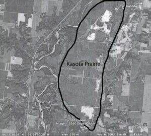
Over the next few months, I discovered that I enjoyed walking and one of my favorite places to walk was the Kasota Prairie. It is about three miles from my house. I hike down Jefferson Avenue from the top of the “Gustie Hill,” then cross Minnesota Avenue (Highway 169), follow the foot/bike path on the Highway 22 bridge over the Minnesota River; take the short-cut up to the old Holiday House restaurant, and turn east onto Rabbit Road. After an hour and a half, I’m in the village of Kasota, Minnesota. This is where the Kasota Prairie begins. It is a piece of land about a mile wide in most places and maybe eight miles long that ends at the northern limits of the city Mankato, MN. It makes up a part of what was once the state’s tall grass prairie region. Most of the millions of acres of this prairie has been put under agricultural cultivation or otherwise developed. The Kasota Prairie is roughly bounded by LeSueur County Road 21 on the east and Kasota Township Road 101 on the west. The Prairie’s western boundary generally parallels the flood plain of the Minnesota River. Highway 169, a major dual lane highway, is immediately to the west of the river. The southern end of the Prairie is where it pinches together near the outskirts of Mankato. I have outlined this area on the accompanying Google Earth satellite image. (see Figure 1. )
On my walk to the Prairie, I would usually take a break at a bench in Kasota’s little town park. Then, I’d head up to the town’s watertower where the old railroad embankment is. I’d follow it south getting great views of the Minnesota River Valley until I reached the intersection of County Roads 21 and 101. It is here that I used to take the gravel road west leading across the Prairie. Only a few years ago there were only a handful of vehicles on this road. Generally, it was quiet and peaceful. It is no longer that way. I can no longer walk there. But before I explain why this has happened, let me return to my former walks on the Prairie.
The Natural Landscape
There are things you can only see when walking the Prairie. I have two favorite plants there. My first is the pasque or wind flower. This is a small, violet-like plant with light purple or white blossoms. It is delicate and blows easily in the wind, hence its name. But what is so neat is that this little dainty plant is the first to bloom in the spring. When you spot pasque flowers on the Kasota Prairie, you can be sure that the red-winged blackbirds and other harbingers of spring can’t be far behind. My second favorite plant is wild asparagus. I’ve spotted some wild asparagus clumps from my car, but not many. You have to be walking to find them, either by seeing the green shoots in early May or where the dead stalks have fallen over from the fall and winter. Finding wild asparagus is not easy, as the old stems get blown down and the young asparagus blends in perfectly with spring grasses which are also turning green. Most wild asparagus hunters, myself included, will never reveal their “ hot spots.” It has taken too much effort to find them. To add to the hunt, wild asparagus is a spring elixir for me. It has a flavor and a quality that no store- bought asparagus can match. I feel I can’t make it into the Spring season without my wild asparagus fix.
Up until a year ago, my wife and I also birded here. What made the Prairie such a good birding area was that it was home to three distinct physical environments. More will be said about them, but suffice it to say there is the prairie, of course, with its array of native plants and grasses such as the well known big and little blue stem. This habitat attracts a distinctive array of prairie-loving birds, such as the Eastern meadowlark, Eastern bluebird, Eastern kingbird, pheasant, and woodcock. What’s sweeter in the summer air than the trill of a meadowlark? The prairie can also surprise you with other birds. We will never forget the sighting of an upland sandpiper many years ago. It was standing on a huge glacial erratic (you’ll find out what those are later). We asked each other, “what were we seeing?” This was a bird of rather large size, white to buff-colored, just standing there. But what was it? After going through two bird books we finally thought it was an upland sandpiper. We saw it for about three years straight on wires or fence posts, but never again on that big erratic. Funny though, on every trip that we’d bird the prairie, we would look for that upland sandpiper on that big erratic.
Just at the edge of the prairie as it butts up to the bluff of the Minnesota River Valley, there is what is called an “oak opening.” This area consists of a mix of deciduous trees- particularly burr oak, but other trees as well, such as maple, elm, and bass wood. These trees provide an ideal environment for woodpeckers such the hairy, downy, and once in a while a red headed or on even more rare occasions, a pileated. There are also the usual assortment of robins, goldfinches, and sparrows of all kinds, most of which I cannot identify even after all these years of birding. And, then there was always the indigo bunting at the same spot year after year. Could it be the same bird returning to the same tree? The warblers came in force during their spring migration. My wife and I would have a contest to see who spotted the first yellow rumped warbler. Then, the stiff neck and frustration of trying to identify all those other warblers would set in.
A river bottom wetland completes the environmental trifecta. It is part of the flat flood plain of the Minnesota River which has been witness to numerous floods and is dotted with marshes and creeks that work their way through the wetlands.This is the primary kingdom of a variety of ducks and geese. It is also the home of shorebirds: sandpipers, yellowlegs, and rails. Belted kingfishers perch on tree branches above the water ready to nose-dive for a meal. But the real treat of the last ten years or so, was the presence of bald eagles roosting and nesting in the trees above the marsh.
There are not many places where the juxtaposition of these three physical environments, prairie, oak opening, and flood plain, are in such a close and accessible space. But the Kasota Prairie is one of them. A well known image of this area is a painting entitled “Pheasants on the Kasota Prairie” by Jerry Raedeke. In the foreground is a cock pheasant flushed from the prairie grass. Strewn on the landscape are those glacial erratics, enormous rocks of boulder size, but no upland sandpiper sitting on them. There are more pheasants and two deer grazing in the background along the Minnesota River. Another feature are limestone pillars capped with mushroom-like heads, locally known as the Garden of the Gods. In the far distance are trees which mark the eastern bluff of the Minnesota River Valley and the boundary of the Kasota Prairie. The painting portrays a “natural” place. There are no houses, no farm fields, no fences, no cars or trucks, and in particular, no railroads or industries. It is a pristine view of the landscape-an unspoiled creation of nature. A Natural Landscape, if you will.
The Industrialized Landscape
There is, however, another Kasota Prairie, but it is the complete opposite of Mr. Raedeke’s painting. It is the image of one of the most highly Industrialized Landscapes in the state. And, like the natural landscape, its existence is based on the unique resources of the prairie, albeit entirely different ones. This Prairie is dominated by white sprawling buildings, railroad cars aligned on the tracks just south of the village of Kasota, massive beige-colored blocks of rock that rest by the quarries from which they came, and huge pits where sand and limestone have been dug from the ground. These images are part of the large mining operations on the Prairie. Most of the mines themselves are hidden from the highways. But from the air, this landscape reveals a spectacular sight. To see this, let us go back to the satellite image we looked at earlier. The “white-like” patches on the image are open pit mines. The patches to the north on the image are the silica sand mines of the Unimin Corporation, which is now owned by SCR-Sibelco of Belgium. The pits to the south and in the central portion of the image are those of the Vetter and SMC stone quarries that are mining Oneota dolomite or limestone. This limestone is one of the most prized building/facing stones in the country with notable uses ranging from the National Museum of the American Indian in Washington, DC and Target Field baseball park in Minneapolis, Minnesota, to name only two. On a tour of the Vetter mining facility some years ago, the limestone was being cut and subsequently delivered for building a shopping mall in Tokyo, Japan. Not only is the Oneota dolomite considered one of the most durable limestones for building, it is also one of the most attractive. And the Vetter and SMC quarries sit atop of one of the largest deposits of this stone in the world.
Unimin Corp, on the other hand, is, according to their web site, the nation’s largest producer of silica sand. It is enjoying a demand for its sand that is unprecedented in the history of the company. The reason for this can be stated in one word: “fracking.” Silica sand is combined with large amounts of water and chemicals to form a solution that is blasted into rock shale formations to break up seams of oil and natural gas. This process is called hydraulic fracturing or “fracking” It is creating a booming economy in North Dakota, Pennsylvania, and Texas, primarily, where oil and natural gas is being mined at an enormous rate. In east Texas alone, 3,100 permits for oil and gas wells were issued between 2011 and 2012 in an area called the Eagle Ford Shale. The critical thing to understand, though, is that fracking can’t be done without silica sand. Thus, there is a great inter-dependence between the oil and gas miners and the sand miners. This is where the Kasota Prairie comes into this inter-dependence. On a visit to their sand mining operations, the folks at Unimin told me to be on the look out for their Winchester and Western sand cars when I went on a recent field trip to see fracking done down deep in the heart of Texas; no pun intended. And sure enough, our second field trip stop was a staging area where silica sand cars come into the mining areas. And there they were, so many Winchester and Western sand cars that I couldn’t count them. And make no mistake about it, this is the world’s best sand for fracking, bar none.
The Two Prairies
The Kasota Prairie, then, is a unique place of two very different landscapes. On the one hand, it is a Natural Landscape. It is the home of one of the remaining tall grass prairies in Minnesota with its assortment of wildlife and plants, a treasure trove for birders and walkers. It is also flanked by an ecologically rich floodplain along one of the state’s largest rivers bordered by an oak opening of hardwood trees. On the other hand, the Kasota Prairie is home to one of the most prized areas for silica sand and limestone mining in the world. Much of the country’s oil and gas mining industries are dependent on this sand resource.
Paul Gruchow’s words in another context continue to ring true. The Prairie has welcomed “strangers” and it still teaches us the virtue of ideas. There have been Native Americans, farmers, and miners bringing to the prairie different ideas for its use. It is environmentally ironic that this place where rock made it so unsuitable for the stranger to plow and farm, thus saving the natural prairie, should now be one of the most advantageous places to mine rock and destroy the prairie.
It is the purpose of this book to help you understand the Natural and Industrialized Landscapes of the Kasota Prairie. To do this, Chapter 1 looks at the meanings of the Dakota Indian word “ka so ta.” Chapter 2 looks at the first man/land interaction on the Prairie; the Native American use of this landscape. Chapter 3 examines the founding of the village of Kasota and its role in the development of the limestone mining industry, while Chapter 4 explores the actual mining from its start to current operations. Chapters 5, 6, and 7 describe the beginning, expansion, and conflict over the mining of silica sand. Finally, Chapter 8 explores the future of the Kasota Prairie.