
1 The Meaning of “Kasota”
In his fabulous book, Where the Waters Gather and the Rivers Meet,[1] Paul Durand has compiled the meanings of landscape terminology employed by the Dakota and Ojibwe peoples. For example,”ma-ka to-o-ze” means, “(a) earth (b) blue or green (c) to take.” This was the Dakota word for the blue earth clay that was taken out of the ground and used as a paint of peace. It was found on the banks of the present-day Blue Earth River, hence the river’s name. The city of Mankato, or more properly Mahato in the Dakota, language, derives its name from the blue earth clay as well.
With regard to “ka-so-ta,” Durand says that it means (a) “to cut off, as in treeless; to make prairie of woodland; and (b) to use up.”[2] Native Americans were very observant of the physical landscape and very adept at applying words that described what they saw and felt about particular places. Their place names were a clear reflection of this. They obviously saw no or few trees here; hence the word ka-so-ta. In other words, it was a prairie.
Their name for this area also seems to imply that a process was taking place or had taken place. The trees had been “cut off” and “used up.” To the biogeographer it makes no sense that the Ka-so-ta landscape was prairie. It is in an environment where climatically trees should be the dominant vegetation type. So, were the Dakota saying that it had been “made” into a prairie? If indeed this was the case, then the Kasota Prairie was a man- (and woman) made landscape. The trees were “cut off” and “used up,” and a grassland prairie was the result. Now, who cut down and used the trees? Was it the Dakota themselves or had someone before them cut off and used up the woodland? I will discuss these questions later.
Another Interpretation of Kasota
Ka-so-ta might also mean that the Minnesota River Valley landscape, largely sculpted thousands of years ago by the Glacial River Warren, also formed the Kasota Prairie. That is, as the Glacial River Warren from the melting ice sheet poured over the landscape, it scoured the land here almost down to the bedrock. That is to say, any surface undulations, such as hills were “cut off.” Pardon the following alcoholic analogy, but it seems to me that this process is akin to how a bartender pours a Guinness in the traditional way in Ireland. The pint, filled about half way, is allowed to set for at least 5-10 minutes. Then, it is filled and what is left of the frothy top is “cut off” with the blade of a table knife, leaving only a very thin foam on top. Could this be a second meaning of ka-so-ta? That during glaciation, a former pre-Glacial River Warren landscape with an uneven land surface was “cut off” almost to the bedrock? It will be the purpose of this chapter to expand on these two meanings of “ka-so-ta.”
Cut-Off Topography
Figure 1. that you looked at earlier in the Introduction, does not show the changes in elevation of the Kasota Prairie. To illustrate this landscape feature or what is called topography, I have included an image of Digital Shaded Relief (see Fig. 2).
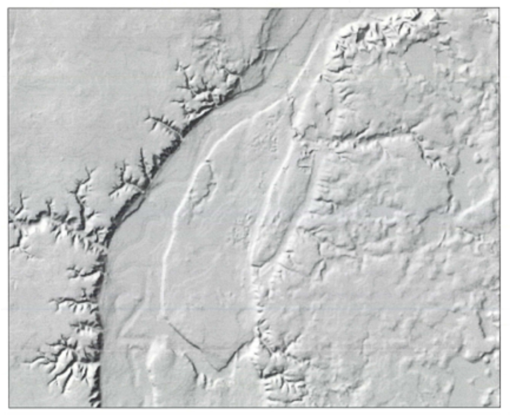
In mapping parlance, Relief is the difference between the highest and lowest elevations in an area. On this image, these numerical differences have been digitized and then shaded or highlighted in tones of gray to show elevation variations. The bluff of the old Glacial River Warren is 1,000 feet or more in elevation and is shown by the dark, almost black band on the left-hand side of the image. The bluff is noticeably eroded and dissected by many spider web-like stream valleys. The Minnesota River and its flood plain are immediately to the right of the bluff. They average approximately 700 feet above sea level. The Kasota Prairie rises almost 70 feet abruptly from the river’s flood plain. The higher ridges or eastern bluff of the Glacial River Warren are adjacent to the Prairie to the east. As the image shows, the Kasota Prairie sits rather like an oblong block in the Minnesota River Valley. Since it is rather flat and in most places cut down to its bedrock, it is known geologically as a bedrock terrace. How did this topographical feature come to be?
To attempt an answer to this question, look at the three cross-sectional profiles (see Fig. 3) drawn by the late Chester Johnson, Emeritus Geology Professor at Gustavus Adolphus College. Chester, who I think knew more about the geological formation of the Minnesota River Valley than anyone else in the state, kindly let me use these profiles. The profiles transect the Minnesota River from west (on the left side of the Figure) to east (on the right hand side). The higher, slightly rolling topography to the west is composed of glacial till.
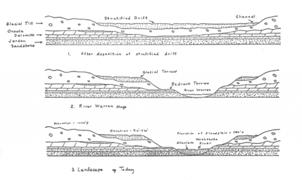
Fig. 3: Cross sectional profiles Minnesota River Valley
This is unsorted materials such as sands and clays and other soil material which was deposited by the glaciers. The till here was left by a glacier called the Des Moines Lobe which was melting away in this area over 10,000-12,000 years ago. Continuing on this top profile we descend to another feature also left by the glacier. This material is called stratified drift and consists of sands and gravels deposited by the melting ice. It is theorized that an earlier and smaller stream which became the major channel for the later River Warren was buried by this glacial material as well as the bedrock layers of Oneota dolomite and Jordan sandstone shown on the profile. Much more will be said later about these two bedrocks, as they are the foundations of the mining industry on the Prairie.
To understand what happened next in the evolution of the Minnesota River valley as shown in the profile called River Warren Stage, we have to go to Big Stone Lake along the Minnesota-South Dakota border. North of Big Stone Lake is Lake Traverse and north of Lake Traverse is a vast expanse of some of the flattest land on earth, known in part as the Red River Valley. Around the margins of this valley are sand and gravel ridges. These are interpreted to represent the shores of a vast ancient lake. This lake is called Lake Agassiz. This lake collected the waters of melting glaciers for many centuries. At its maximum extent during the glacial period, Lake Agassiz covered an area of 200,000 square miles and had a maximum depth of 750 feet. The extent of this lake was larger in size than all of the present Great Lakes combined. Some rather sizable remnant lakes, including Lake Winnipeg, Lake of the Woods and Upper and Lower Red Lakes, occupy large depressions today in the bed of ancient Lake Agassiz.
Lake Agassiz existed in this location because it was damned on the south and west by highlands. For how long, no one really knows. Then, somehow this dam broke and through this outlet poured the overflow water from this huge lake. A gigantic river called the Glacial River Warren was created. It was named after General G. K. Warren, who was the first to publish a description of it. At its height, it ranged from 1-5 miles wide and 75-100 ft. deep. It seems to have flowed down the buried channel of the “old” Minnesota River. Radiocarbon dates suggest that this episode began about 12,000 years ago. As the middle profile shows, the river aggressively cut down through the stratified drift, the glacial till, and eroded many areas down to the bedrock (limestone and sandstone) surfaces. Subsequently other outlets were opened, first to the east where Lake Agassiz drained into what is now Lake Superior by way of Rainy Lake and other waterways east of that. As these diversions occurred, the River Warren shrank to its present size which we now call the Minnesota River.
The landscape that we see today (the lowest profile in Fig. 3), is largely the creation, then, of its former colossal predecessor, the Glacial River Warren. The enormous river valley which it cut is about 225 miles long and 1-5 miles wide. Geomorphologists call the Minnesota River Valley a mis-fit stream, as the size of the river is much smaller or does not “fit” the much bigger valley in which it flows. The Kasota Prairie, as mentioned earlier, sits on a bedrock terrace which was created by the erosional effects of the Glacial River Warren. The bedrock of Oneota dolomite and Jordan sandstone is thus in some places very near the ground surface. What is highly interesting, as you walk or drive across the Prairie, are the large boulder-like glacial erratics that dot the landscape. They consist of granite and other igneous rock which were moved by the glaciers from somewhere else. Hence, they are foreign or erratic to the area. This is one piece of evidence that glaciers were shaping the present-day Minnesota River Valley.
The general impact, then, of the River Warren was to scrape away any former landscape leaving a largely flat to gently rolling place dotted by huge erratics, a place where the landscape was “cut off” or worn down to its bedrock. In terms of the other meaning of the word “ka-so-ta” did it also mean the vegetation here was“cut-off’ as well?
Cut-Off Vegetation
Look again at the satellite image in the introduction (Fig. 1). The winding line on this image is the Minnesota River. The dark-colored areas of irregular shape adjacent to the river are forest bottomland interspersed with grasses and brush. This is the river’s flood plain. To the west of the river valley is a patchwork of farm fields and scattered farmsteads, drained by wooded valley streams. And, of course, the Kasota Prairie is to the east of the river and its flood plain. Further to the east is the beginning of a largely hardwood forest, known as the Big Woods. Now, let us examine these geographical settings in terms of their historic vegetation environments.
In 1930, a research assistant at the United States Department of Agriculture (USDA) Bureau of Agricultural Economics, Francis Marschner, produced a map entitled, “The Original Vegetation of Minnesota”.[3] On it, he mapped areas of the state that prior to European settlement were in various types of vegetation cover, such as Prairie Grassland, Wet Prairie, Marshes and Sloughs (Flood Plain), Oak Openings, Mixed Hardwoods,including the Big Woods, and other types. Although scholars are unclear of the exact methods he employed to produce this map, it is assumed that Marschner used the notes and maps made by the General Land Office (GLO) in their land surveys of Minnesota conducted from 1847-1907. If this indeed was the case, Marschner would have had to have read 200 volumes of the GLO field notes and then transfer them by hand onto a 1:500,000 scale map of his own making. No small task, but indeed one that has made his map one of the most valued research tools for biogeographers, plant ecologists, agricultural economists, and many other scholars.
Again, remember the Kasota Prairie is located between the Big Woods to the east and the marshes and flood plain of the Minnesota River. The Big Woods consisted of an area of predominantly oaks, elm, basswood, ash, maple, hickory, walnut and other hardwood tree species. The Wet Prairie classification included occasional marshes interspersed within the tall prairie grasslands of big and little blue stem, turkey foot and other grasses. According to Marschner, the Kasota Prairie is part of the vast Wet Prairie vegetation region to the west of the Minnesota River.
The question I wish to ask is “why should the Kasota Prairie be classified as a wet prairie, rather than part of the Big Woods, which it butts up against?” I will offer a possible answer for this question, based on Marrchner’s meaning of the word “Original” and the second interpretation of the word, ka-so-ta.
Marschner claimed he was mapping the “original vegetation.” This would have been the native or natural vegetation that existed on the eve of European settlement of the state. What is implied is after European settlement, the vegetation was no longer “original.” What this also implies is that although Native Americans lived on this landscape for thousands of years, they did not alter it or transform it, at least not in any major way. What the Europeans had presented before them–to use as they saw fit–was interpreted as a largely pristine, unspoiled landscape. It was not one modified by the Indians. It was “Original.”
Such an implication of landscape history could not be further from the truth. There are many studies that show that Native Americans created large areas of prairie from forested areas in their use of the land. How did this happen?
The historical geographer, Carl Sauer, was the first to theorize, as far as I know, that Native Americans created much, if not all, of the prairie in North America.[4] This was accomplished on a massive geographic scale by the use of fire as both a hunting device and an ecological device. Native Americans moved with the herds of mammoth, mastodon, and other big game animals. Their hunting skills were greatly aided by the use of fire. Fires were set to drive and frighten these large animals into ravines or over cliffs that would wound them. The hunters could then get close enough to kill these big animals with flint-tipped spears. It is thought that without fire drives, this would’ve been impossible. But a fire drive would not only burn grasses, it would also kill trees. High winds on a dry landscape could result in an out-of-control fire. Such a fire would burn many grasses, bushes, and trees over a large area.The next year the grasses would start to grow back more lush than before, but not the trees. They were dead; thus, a grassland prairie was born.
Some scholars also believe that once the prairie was created, fire was equally useful to maintain this ecosystem. Continual burning of the grasslands not only prevented forests from re-establishing, but made the grasses of the prairie come back stronger and thicker after every spring. This is exactly what prairie restoration seeks to do today. To keep and maintain a vibrant prairie, one must periodically burn it.
Now, consider this in the context of the Dakota meaning of the word “Kasota.” Again, according to Durand, it means “to cut all off, as trees; to make prairie of woodland.” It is my contention that the Kasota Prairie was Native American-made by repeated burnings, just like the prairie is maintained today.
Throughout the Midwest, European settlers and explorers found prairie that by all climatological rights should have been forests. Moisture is aplenty for trees on the Kasota Prairie. It was in fact right next to a forest, the Big Woods. But, it is largely “treeless.” Why? Is it because the trees were periodically burned and not allowed to grow back? Was the Kasota Prairie created by Native Americans who for their livelihood wanted to keep it that way? It clearly was not and is not “original” vegetation. Now, just who were these early prairie environmental managers? That question is the purpose of the next chapter.
- Paul Durand, Where the Waters Gather and the Rivers Meet, Paul C.Durand, Prior Lake, Minnesota, 1994, p .43 ↵
- Ibid, p. 40. ↵
- Francis Marschner, “Map of the Original Vegetation of Minnesota,” North Central Forest Experiment Station, Forest Service, United States Department of Agriculture, St. Paul, MN, 1930. ↵
- Carl O. Sauer, “A Geographic Sketch of Early Man in America,” Land and Life: A Selection from the Writings of Carl Ortwin Sauer, University of California Press, 1963. ↵